Navala Village Online Map:
Navala Village Online Map is developed with ESRI ArcGIS and MapViewSVG. It does not only contain geographical information on Navala but also some geographical information on Fiji . The scalable range of the map is from Navala village (1:1500) to the
Fiji-coastline (1: 5 000 000).
How to use Navala Village Online Map
1. Switch between different map views
The original view is Navala Village. You can zoom between Navala, Ba province, Viti Levu island and Fiji by using ![]()
![]() . Wherever you are,
. Wherever you are, ![]() can take you back to the Navala village view.
can take you back to the Navala village view.
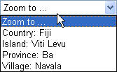
dropdown menu to switch between the Fiji, Viti Levu, Ba and Navala views.
2. Get further information
Navala Village Online GIS also contains some other informations than map information, such as special houses' picture and description, data on population statistics in districts of Viti Levu and in different provinces of Fiji. In the Navala village view, activate the  button, then the cursor will change to
  when you move the mouse over some of the houses. Click this house, and you will get detailed information in a newly opened window. In the front of "Viti_Districts" and "Province" layers on the map legend, there is one
  button. By clicking this button, you can get Information about the population of Viti_Levu districts or Fiji.
For more information about how to use Navala Online Map, please click the ![]() tool on the map.
tool on the map.